Datoteka:World Köppen Map.png

Veličina ovog prikaza: 800 × 530 piksela. Ostale razlučivosti: 320 × 212 piksela | 640 × 424 piksela | 1.024 × 679 piksela | 1.280 × 848 piksela | 2.560 × 1.697 piksela | 4.231 × 2.804 piksela.
Vidi sliku u punoj veličini (4.231 × 2.804 piksela, veličina datoteke: 1,05 MB, MIME tip: image/png)
| Ova je datoteka sa Zajedničkog poslužitelja i mogu je rabiti drugi projekti. Opis s njezine stranice s opisom datoteke prikazan je ispod. |

|
This meteorology image could be re-created using vector graphics as an SVG file. This has several advantages; see Commons:Media for cleanup for more information. If an SVG form of this image is available, please upload it and afterwards replace this template with
{{vector version available|new image name}}.
It is recommended to name the SVG file “World Köppen Map.svg”—then the template Vector version available (or Vva) does not need the new image name parameter. |
Sažetak
| Opis |
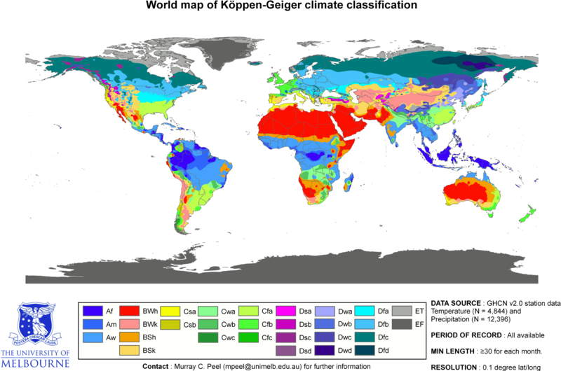
English: Updated world map of the Köppen-Geiger climate classification. Français : Carte du monde mise à jour de la classification Köppen-Geiger des climats.
|
|||||||||||||||
| Datum | ||||||||||||||||
| Izvor | Peel, M. C. and Finlayson, B. L. and McMahon, T. A. (2007). "Updated world map of the Köppen-Geiger climate classification". Hydrology Earth and System Sciences 11: 1633-1644. ISSN 1027-5606. | |||||||||||||||
| Autor |
Peel, M. C., Finlayson, B. L., and McMahon, T. A. (University of Melbourne). |
|||||||||||||||
| Dopuštenje (Naknadna uporaba ove datoteke) |
||||||||||||||||
| Ostale inačice | Radovi izvedeni od ove datoteke: Köppen World Map (retouched version).png | |||||||||||||||
.png)
Related maps
User Jeroenvrp made for these continents and areas a cropped and resized version:
- Africa Köppen Map.png
- Asia Köppen Map.png
- Australia-Oceania Köppen Map.png
- Europe Köppen Map.png
- North America Köppen Map.png
- Russia Köppen Map.png
- South America Köppen Map.png
- West Asia Köppen Map.png.
User LordToran made from the same data these maps:
- Klimagürtel-der-erde-eisklima.png
- Klimagürtel-der-erde-gemäßigte-zone.png
- Klimagürtel-der-erde-polargebiete.png
- Klimagürtel-der-erde-subtropen.png
- Klimagürtel-der-erde-tropen.png
- Klimagürtel-der-erde-tundra.png
- Klimagürtel-der-erde-warmgemäßigte-zone.png
- Klimagürtel-der-erde.png
- Klimagürtel-der-erde.svg
- Klimate-humidität.png
- Köppen-geiger-hessd-2007.svg
- Köppen-vereinfacht.svg
- Trockenklimate.png
Licencija
Ova datoteka je licencirana pod Creative Commons Imenovanje-Dijeli pod istim uvjetima 3.0 nelokaliziranom licencijom.
- Slobodno smijete:
- dijeliti – umnožavati, distribuirati i javnosti priopćavati djelo
- remiksirati – prerađivati djelo
- Pod sljedećim uvjetima:
- imenovanje autora – Morate pripisati odgovarajuće autorske zasluge, dati poveznicu na licenciju, te naznačiti jesu li načinjene promjene autorskog djela. Prethodno navedeno možete učiniti na svaki razuman način, ali ne na način koji bi sugerirao da Vi ili Vaše korištenje licencorova djela ima izravno licencorovo odobrenje.
- dijeli pod istim uvjetima – Ako ovo djelo izmijenite, preoblikujete ili stvarate na osnovu tog materijala, svoje doprinose morate distribuirati pod istom ili kompatibilnom licencijom kao što je i licencija originala.
Povijest datoteke
Kliknite na datum/vrijeme kako biste vidjeli datoteku kakva je tada bila.
| Datum/Vrijeme | Minijatura | Dimenzije | Suradnik | Komentar | |
|---|---|---|---|---|---|
| sadašnja | 19:15, 13. lipnja 2018. | | 4.231 × 2.804 (1,05 MB) | Trecătorul răcit | Correct areas of the Pyreneos, Alps, Carpathes, Balkans and Caucasus |
| 17:57, 20. veljače 2018. |  | 4.231 × 2.804 (1,05 MB) | Maphobbyist | The Caspian coastal lowland of Iran has a humid subtropical climate (Köppen classification: Cfa). | |
| 21:26, 24. lipnja 2017. |  | 4.231 × 2.804 (742 KB) | Alatab | Costa Rican Central Valley has a Cwb clasification (Oceanic climate). | |
| 01:59, 25. rujna 2016. |  | 4.231 × 2.804 (786 KB) | Maphobbyist | Köppen system is based on the concept that climate types are correlated with the natural vegetation. | |
| 23:08, 21. lipnja 2013. |  | 4.231 × 2.804 (336 KB) | Underlying lk | derivative works based on this map should be uploaded with a different name, rather than overwrite the original UoM file. | |
| 14:13, 13. ožujka 2011. |  | 4.231 × 2.804 (1,11 MB) | Maphobbyist | Painted the Caspian Sea as white as it should have been, because the Köppen system is based on the concept that climate types are correlated with the natural vegetation. Thus with Köppen, climate zone boundaries have been selected with vegetation distri | |
| 01:41, 6. ožujka 2010. |  | 4.231 × 2.804 (336 KB) | Aiyizo | Cropped white space, compressed with pngout. I've also converted the image to indexed mode with an optimal 64 color palette. This introduces minor alaising effects to the region edges, but it gives a massive reduction in file size. I think this is a go | |
| 00:35, 13. listopada 2007. |  | 4.250 × 2.815 (2,09 MB) | Jeroen | ||
| 00:05, 13. listopada 2007. |  | 6.708 × 4.443 (3,21 MB) | Jeroen | Citation: '''Peel, M. C., Finlayson, B. L., and McMahon, T. A.: Updated world map of the Köppen-Geiger climate classification, Hydrol. Earth Syst. Sci., 11, 1633-1644, 2007.''' {{Information |Description= Updated world map of the Köppen-Geiger climate |
Uporaba datoteke
Na ovu sliku vode poveznice sa sljedećih stranica:
Globalna uporaba datoteke
Sljedeći wikiji rabe ovu datoteku:
- Uporaba na an.wiki.x.io
- Uporaba na bg.wiki.x.io
- Uporaba na bs.wiki.x.io
- Uporaba na ca.wiki.x.io
- Clima
- Climatologia
- Clima mediterrani
- Clima continental
- Clima atlàntic
- Clima temperat
- Classificació climàtica de Köppen
- Clima tropical
- Clima equatorial
- Clima polar
- Plantilla:Climes
- Clima àrid
- Categoria:Climes tipus
- Semidesert
- Wladimir Köppen
- Clima subtropical humit
- Clima de la sabana
- Clima tropical monsònic
- Uporaba na cs.wiki.x.io
- Uporaba na da.wiki.x.io
- Uporaba na en.wiki.x.io
- Uporaba na en.wikibooks.org
- Uporaba na et.wiki.x.io
- Uporaba na fr.wiki.x.io
- Uporaba na fy.wiki.x.io
- Uporaba na he.wiki.x.io
- Uporaba na hi.wiki.x.io
- Uporaba na id.wiki.x.io
- Uporaba na it.wiki.x.io
- Uporaba na ja.wikibooks.org
- Uporaba na kk.wiki.x.io
- Uporaba na li.wiki.x.io
Pogledajte globalnu uporabu ove datoteke.