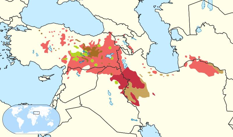
Datoteka:Kurdish languages map.svg

Veličina ovog PNG prikaza ove SVG datoteke: 800 × 472 piksela. Ostale razlučivosti: 320 × 189 piksela | 640 × 377 piksela | 1024 × 604 piksela | 1280 × 755 piksela | 2560 × 1509 piksela | 950 × 560 piksela.
Vidi sliku u punoj veličini (SVG datoteka, nominalno 950 × 560 piksela, veličina datoteke: 4,44 MB)
Povijest datoteke
Kliknite na datum/vrijeme kako biste vidjeli datoteku kakva je tada bila.
| Datum/Vrijeme | Minijatura | Dimenzije | Suradnik | Komentar | |
|---|---|---|---|---|---|
| sadašnja | 00:32, 7. prosinca 2022. |  | 950 × 560 (4,44 MB) | Semsûrî | Rv unsourced map |
| 02:16, 5. prosinca 2022. |  | 950 × 560 (4,54 MB) | Heviyane | Reverted to previous map. The previous map was deemed reliable and the new map messes lots of wikipedia articles up as the colors were changed. | |
| 21:24, 29. rujna 2022. |  | 950 × 560 (4,44 MB) | Semsûrî | Revert to original Izady map before unsourced additions took over | |
| 17:11, 11. listopada 2019. |  | 950 × 560 (4,54 MB) | SharabSalam | Redraw the border of Israel; Golan heights are not part of Israel according to the UN | |
| 18:02, 6. prosinca 2018. |  | 950 × 560 (5,62 MB) | Taysheyi | Changed to softer and easier to spot colors. Changed Southern Kurdish border as there are non Central Kurdish speakers south of the Southern Kurdish speakers. Map is largely based upon (Öpengin, 2013) as well as Izady's Distribution of Kurdish Language and its Major Dialects | |
| 11:55, 23. travnja 2015. |  | 950 × 560 (4,44 MB) | Taysheyi | Added other Gorani-speakers in Iraq | |
| 14:15, 21. travnja 2015. |  | 950 × 560 (4,44 MB) | Taysheyi | No Zazaki-speakers in Iraq | |
| 14:15, 21. travnja 2015. |  | 950 × 560 (4,44 MB) | Taysheyi | No Zazaki-speakers in Iraq | |
| 13:31, 21. travnja 2015. |  | 950 × 560 (4,44 MB) | Taysheyi | Fixed Southern Kurdish Iraqi border. Changed colors of Zazaki and Gorani. Made Gorani-speakers softer. | |
| 17:59, 20. travnja 2015. |  | 950 × 560 (4,44 MB) | Taysheyi | More accurate location of Gorani-speakers |
Uporaba datoteke
Na ovu sliku vode poveznice sa sljedećih stranica:
Globalna uporaba datoteke
Sljedeći wikiji rabe ovu datoteku:
- Uporaba na af.wiki.x.io
- Uporaba na ar.wiki.x.io
- Uporaba na ast.wiktionary.org
- Uporaba na bcl.wiki.x.io
- Uporaba na bg.wiki.x.io
- Uporaba na br.wiki.x.io
- Uporaba na ckb.wiki.x.io
- Uporaba na cs.wiki.x.io
- Uporaba na da.wiki.x.io
- Uporaba na de.wiki.x.io
- Uporaba na de.wikinews.org
- Uporaba na en.wiki.x.io
- Kurdish language
- Sorani
- Southern Kurdish
- Kurmanji
- Kurds in Syria
- Talk:List of active separatist movements in Asia/Archive 1
- User:Kazkaskazkasako/Books/History
- Template:Portal/doc/all
- Template:Noticeboard box/sandbox
- Syrian Kurdistan
- Kurdish phonology
- Template:Regional notice board box
- Template:Regional notice board box/doc
- User:Zemen
- Secession in Turkey
- Talk:Secession in Turkey
- User:GPinkerton/sandbox/Syrian Kurdistan
Pogledajte globalnu uporabu ove datoteke.