Datoteka:Kingdom of Hungary counties.svg

Veličina ovog PNG prikaza ove SVG datoteke: 779 × 513 piksela. Ostale razlučivosti: 320 × 211 piksela | 640 × 421 piksela | 1.024 × 674 piksela | 1.280 × 843 piksela | 2.560 × 1.686 piksela.
Vidi sliku u punoj veličini (SVG datoteka, nominalno 779 × 513 piksela, veličina datoteke: 235 KB)
| Ova je datoteka sa Zajedničkog poslužitelja i mogu je rabiti drugi projekti. Opis s njezine stranice s opisom datoteke prikazan je ispod. |
Sažetak
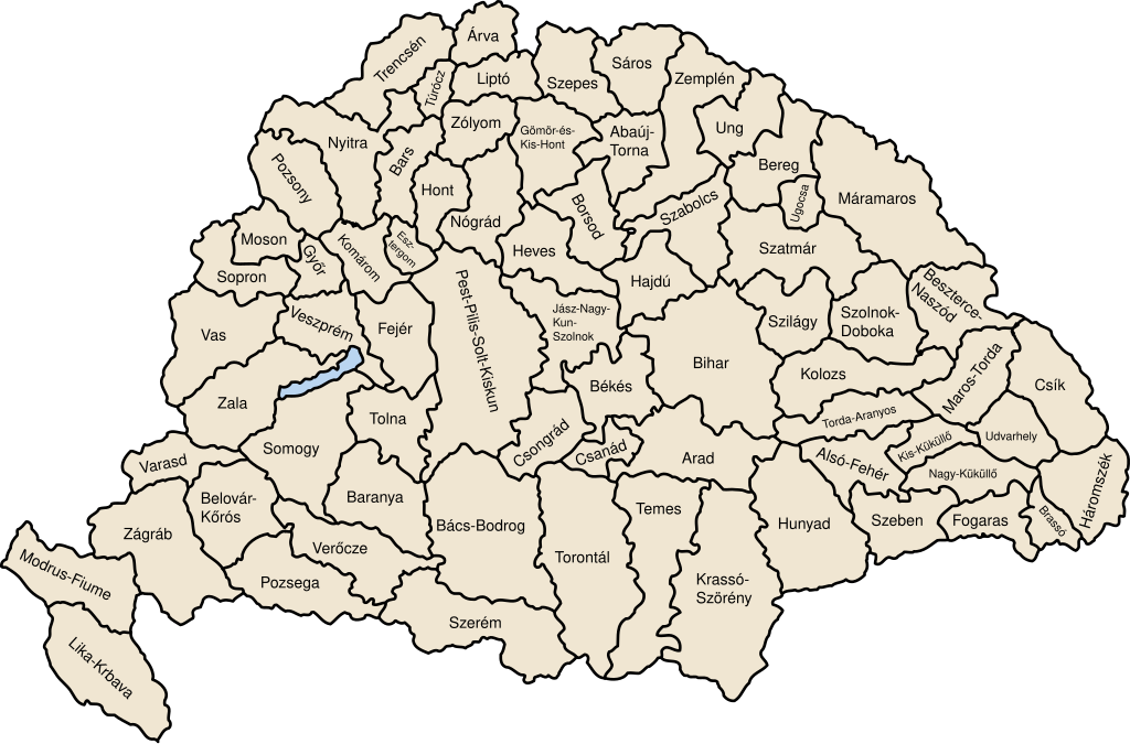
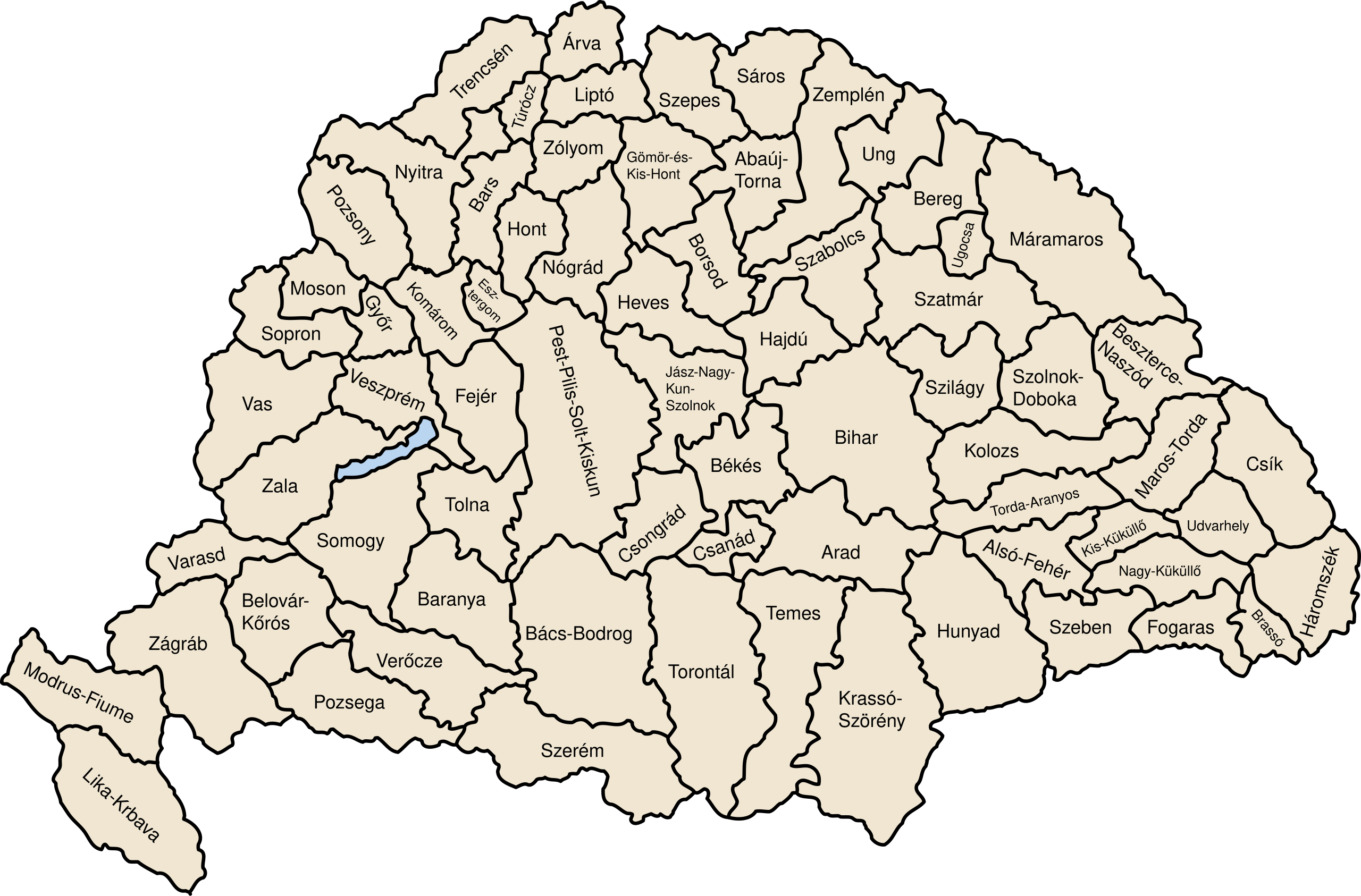
| Opis | Map of counties of Kingdom of Hungary (Hungary proper and Croatia & Slavonia), 1886-1918 |
| Datum | |
| Izvor | Vlastito djelo postavljača |
| Autor | User:IMeowbot |
| Ostale inačice | Radovi izvedeni od ove datoteke: Kingdom of Hungary counties-2.svg |
| SVG development | W3C-validity not checked. |
Licencija
| Ja, nositelj autorskog prava za ovo djelo, prepuštam ovo djelo u javno vlasništvo. Ovo prepuštanje vrijedi za cijeli svijet. U nekim državama to nije pravno moguće; ako je tako: Dajem svima prava da koriste ovo djelo za bilo koju svrhu, bez ikakvih uvjeta, osim ako takvi uvjeti nisu propisani zakonom. |
Povijest datoteke
Kliknite na datum/vrijeme kako biste vidjeli datoteku kakva je tada bila.
| Datum/Vrijeme | Minijatura | Dimenzije | Suradnik | Komentar | |
|---|---|---|---|---|---|
| sadašnja | 09:41, 19. srpnja 2023. | | 779 × 513 (235 KB) | Alphathon | Reverted to version as of 22:47, 16 August 2022 (UTC). Bars/Hont and Csongrád/Bács-Bodrog borders are inaccurate, several more are distored (most only slightly) and the file is a "FakeSVG" – a raster image using an SVG as a container with no actual vector elements. |
| 00:43, 21. siječnja 2023. |  | 8.277 × 5.472 (589 KB) | Ascended Dreamer | Added FIume and increased line weight | |
| 00:31, 21. siječnja 2023. |  | 8.277 × 5.472 (607 KB) | Ascended Dreamer | Increased border accuracy | |
| 00:47, 17. kolovoza 2022. |  | 779 × 513 (235 KB) | Alphathon | corrected õ → ő (tilde → double accute) | |
| 19:53, 5. prosinca 2009. |  | 779 × 513 (235 KB) | SimonTrew | Fix spelling error Veszprém. | |
| 16:24, 3. prosinca 2009. |  | 779 × 513 (235 KB) | SimonTrew | Fixed spelling of "Poszsony" -> "Pozsony". | |
| 22:25, 20. kolovoza 2007. |  | 779 × 513 (235 KB) | Xavax | == Summary == {{Information| |Description= Map of counties of Hungary with Croatia & Slavonia, 1886-1918 |Source=own drawing |Date=April 30, 2006 |Author=User:IMeowbot |Permission= |other_versions= }} == Licensing == {{PD-self}} <!--Categories--> [[ | |
| 00:10, 1. svibnja 2006. |  | 779 × 513 (223 KB) | IMeowbot~commonswiki | line weight | |
| 23:34, 30. travnja 2006. |  | 779 × 513 (221 KB) | IMeowbot~commonswiki | ||
| 20:34, 30. travnja 2006. |  | 779 × 513 (195 KB) | IMeowbot~commonswiki | {{Information| |Description= Map of late 1870s Hungary counties |Source=own drawing |Date=April 30, 2006 |Author=User:IMeowbot |Permission= |other_versions= }} |
Uporaba datoteke
Na ovu sliku vode poveznice sa sljedećih stranica:
Globalna uporaba datoteke
Sljedeći wikiji rabe ovu datoteku:
- Uporaba na als.wiki.x.io
- Uporaba na an.wiki.x.io
- Uporaba na ar.wiki.x.io
- Uporaba na azb.wiki.x.io
- Uporaba na bg.wiki.x.io
- Uporaba na bn.wiki.x.io
- Uporaba na ca.wiki.x.io
- Uporaba na cs.wiki.x.io
- Uporaba na cy.wiki.x.io
- Uporaba na de.wiki.x.io
- Uporaba na el.wiki.x.io
- Uporaba na en.wiki.x.io
- Liptó County
- Zemplén County
- Hont County
- Bars County
- Turóc County
- Brassó County
- Bihar County
- Kingdom of Hungary
- Esztergom County
- Pozsony County
- Nyitra County
- Moson County
- Sopron County
- Bács-Bodrog County
- Heves County (former)
- Jász-Nagykun-Szolnok County (former)
- Trencsén County
- Zólyom County
- Pest-Pilis-Solt-Kiskun County
- Komárom County
- Bereg County
- Borsod County
- Ung County
- Hajdú County
- Máramaros County
- Szabolcs County
- Szatmár County
Pogledajte globalnu uporabu ove datoteke.