Datoteka:Islands off the Croatian Coast (cropped to Rab N).jpg
Viša rezolucija nije dostupna.
Islands_off_the_Croatian_Coast_(cropped_to_Rab_N).jpg (300 × 300 piksela, veličina datoteke: 71 KB, MIME tip: image/jpeg)
| Ova se datoteka nalazi na Zajedničkom poslužitelju i mogu je rabiti drugi projekti. Ispod je prikazan opis s njezine tamošnje stranice. |
Sažetak
| Opis |
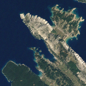
English: This picture shows some of the Croatian Islands in the Adriatic Sea. Image captured by the Enhanced Thematic Mapper (ETM) on NASA’s Landsat 7 satellite. Landsat data provided by the United States Geological Survey. |
| Datum | |
| Izvor | NASA Earth Observatory |
| Autor | Jesse Allen and Robert Simmon |
| Ostale inačice |

.jpg)
Licencija
| This file is in the public domain in the United States because it was solely created by NASA. NASA copyright policy states that "NASA material is not protected by copyright unless noted". (See Template:PD-USGov, NASA copyright policy page or JPL Image Use Policy.) | ||
 |
Warnings:
|
| Annotations | This image is annotated: View the annotations at Commons |
Povijest datoteke
Kliknite na datum/vrijeme kako biste vidjeli datoteku kakva je tada bila.
| Datum/Vrijeme | Minijatura | Dimenzije | Suradnik | Komentar | |
|---|---|---|---|---|---|
| sadašnja | 08:30, 3. svibnja 2022. | | 300 × 300 (71 KB) | Argo Navis | File:Islands off the Croatian Coast.jpg cropped 93 % horizontally, 93 % vertically using CropTool with precise mode. |
Uporaba datoteke
Na ovu sliku vode poveznice sa sljedećih stranica:
.jpg)