Datoteka:A view on 6th to 8th century ethnic distribution in Romania.png
Veličina ovog prikaza: 659 × 599 piksela. Ostale razlučivosti: 264 × 240 piksela | 528 × 480 piksela | 1.003 × 912 piksela.
Vidi sliku u punoj veličini (1.003 × 912 piksela, veličina datoteke: 58 KB, MIME tip: image/png)
| Ova je datoteka sa Zajedničkog poslužitelja i mogu je rabiti drugi projekti. Opis s njezine stranice s opisom datoteke prikazan je ispod. |

|
This ethnographic map image could be re-created using vector graphics as an SVG file. This has several advantages; see Commons:Media for cleanup for more information. If an SVG form of this image is available, please upload it and afterwards replace this template with
{{vector version available|new image name}}.
It is recommended to name the SVG file “A view on 6th to 8th century ethnic distribution in Romania.svg”—then the template Vector version available (or Vva) does not need the new image name parameter. |
Sažetak
| Opis |
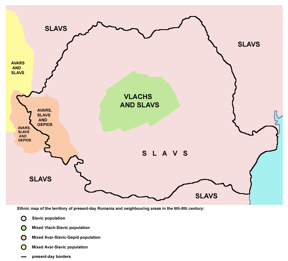
English: A view on 6th to 8th century AD ethnic distribution in the territory of present-day Romania and neighbouring areas. It is based on the historical atlas for schools, "Školski istorijski atlas, Zavod za izdavanje udžbenika SR Srbije", published in Belgrade in 1970 and representing information from Yugoslav sources at that time. See also References below. |
| Izvor | Vlastito djelo postavljača. Created according to the map from this history atlas: "Školski istorijski atlas, Zavod za izdavanje udžbenika SR Srbije", Belgrade, 1970. |
| Autor | PANONIAN |
Licencija
| Ja, nositelj autorskog prava za ovo djelo, prepuštam ovo djelo u javno vlasništvo. Ovo prepuštanje vrijedi za cijeli svijet. U nekim državama to nije pravno moguće; ako je tako: Dajem svima prava da koriste ovo djelo za bilo koju svrhu, bez ikakvih uvjeta, osim ako takvi uvjeti nisu propisani zakonom. |
References
Main reference:
- Created according to the historical map from this history atlas: "Školski istorijski atlas, Zavod za izdavanje udžbenika SR Srbije, Beograd, 1970."
Secondary references (with similar maps):
- The Times - Atlas Svjetske Povijesti, Dopunjeno izdanje za Jugoslaviju, Cankarjeva založba, Ljubljana, 1986. - this is Yugoslav (Serbo-Croatian) edition of this original source: The Times Atlas of World History, Times Books Limited, London, 1984. (in Yugoslav version from 1986 there is similar map on page number 298)
- Denis Šehić - Demir Šehić, Istorijski atlas Sveta, Beograd, 2007. (similar map is published on page number 29)
- The former Yugoslavia's diverse peoples: a reference sourcebook By Matjaž Klemenčič, Mitja Žagar: https://books.google.com/books?id=ORSMBFwjAKcC&pg=PA3&lpg=PA5&vq=maps&output=html (a source with similar map published on page number 3)
- Here are external links with similar maps:
Povijest datoteke
Kliknite na datum/vrijeme kako biste vidjeli datoteku kakva je tada bila.
| Datum/Vrijeme | Minijatura | Dimenzije | Suradnik | Komentar | |
|---|---|---|---|---|---|
| sadašnja | 02:50, 17. veljače 2010. | | 1.003 × 912 (58 KB) | PANONIAN | included Gepids |
| 23:52, 9. veljače 2010. |  | 977 × 852 (51 KB) | PANONIAN | {{Information |Description={{en|1=Ethnic map of the territory of present-day Romania and neighbouring areas in the 6th-8th century (according to the historical atlas for schools, published in Belgrade in 1970, representing a view of Yugoslav historians fr |
Uporaba datoteke
Na ovu sliku vode poveznice sa sljedećih stranica:
Globalna uporaba datoteke
Sljedeći wikiji rabe ovu datoteku:
- Uporaba na ca.wiki.x.io
- Uporaba na ce.wiki.x.io
- Uporaba na cv.wiki.x.io
- Uporaba na en.wiki.x.io
- Uporaba na fr.wiki.x.io
- Uporaba na he.wiki.x.io
- Uporaba na id.wiki.x.io
- Uporaba na ro.wiki.x.io
- Uporaba na ru.wiki.x.io
- Uporaba na sh.wiki.x.io
- Uporaba na sk.wiki.x.io
- Uporaba na sr.wiki.x.io
- Uporaba na uk.wiki.x.io
- Uporaba na uz.wiki.x.io
- Uporaba na zh.wiki.x.io